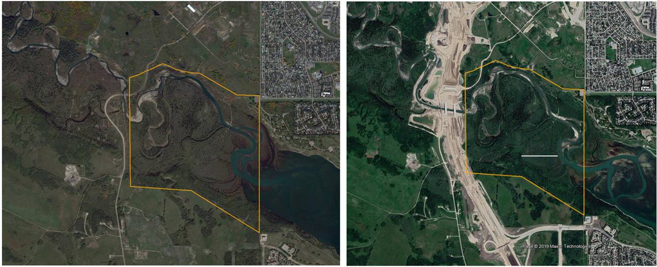
The South West Calgary Ring Road (SWCRR) is currently under construction along the western boundary of the Weaselhead. The above satellite images show the park (outlined in orange) before construction started in 2016, and three years late in 2019. An aerial photo record of the changes can be seen on the Society’s photographic website. Details of the contract, including Schedule 18 that details the environmental mitigation measures required are available on the Alberta Transportation website.
The Weaselhead/Glenmore Park Preservation Society worked hard, initially to prevent the road taking this route and then once this route was decided upon by the Province, to argue for a less environmentally impactful design: an open-span bridge across the valley and no re-alignment of the Elbow River (rather than building a 5 – 10m high berm across the floodplain to carry the road with bridges that spanned the river only. This design required moving 1.2km of the river to a new man-made channel). A video of the public forum organised in 2014 to discuss concerns and argue for improved mitigation measures (including an open-span bridge) is available here. Although The Society was not successful in getting the design of the river crossing changed, the bridges (north bound, southbound, and local) across the river were significantly lengthened to create two wildlife corridors under the bridges, one on each bank. Other modifications were the addition of trees and shrubs in the median to help birds cross the highway; an additional riparian native seed mix for re-vegetation of the valley post construction; and a realignment of the road to reduce the infilling of a wetland in the Weaselhead from 29% to 5%. This was further reduced following an environmental appeal in 2017 (the submissions and outcomes of the Appeal by ‘YYCCares‘ can be downloaded here). This resulted in the contractor building a retaining wall between the road and the wetland to avoid the need for any infilling.
In 2015 the Society commissioned a study (the SWCRR Impact Study) to measure the impacts of the SWCRR from construction to completion on terrestrial and aquatic ecosystems in the Weaselhead. The short-term aim of the Study is to ensure that any immediate concerns (such as accidental spills of material from the construction site into nearby wetlands, example here and here) are noticed and action taken. The long-term aim is an objective evaluation of road’s environmental effects and of the success of the mitigation measures that have been adopted, and to provide evidence for improved mitigation if required. This long-term study will also help improve global road mitigation efforts by providing a case-study that compares data from ‘before’, ‘during’ and ‘after’ construction.
As part of the Study the Society is also gathering information on the effect of the SWCRR project on park-users: if their use of the park changes and whether its value as an amenity to Calgarians changes. This information is obtained from surveys conducted in the park, but you also can contribute by filling in an online survey. Let us know what you value most about the Weaselhead (and what you don’t like!).
A comprehensive description of the route, the current agreement and the long history of this project are available on a local historian’s blog. and to see what a drive on the SWCRR might be like, watch the animation below. The coming of the ring road is also opening up areas next the park for development. To see the Tssut’ina Nation’s planned developments on the north and south side of the Weaselhead/Glenmore Parks go again to Jesse Salus’ site and/or watch this video presentation.
(Animation of crossing the Elbow Valley, Weaselhead on left and new stormwater ponds visible on right, starts at 1.25 mins.)